
According to the latest Global Seasonal Climate Update from the World Meteorological Organization (WMO), strong El Niño weather conditions are likely to develop as early as May–July 2026. Some experts have reported it as a ‘Super El Nino,’ meaning high-impact weather conditions may form in the coming season. This may push global temperatures to record highs and impact rainfall patterns worldwide. This entire process is called ENSO ( El Nino-southern Oscillation). ENSO consists of a warm phase, El Niño, and a cold phase, La Niña. Let’s break down these phases and their impact, one by one.
What is El Niño or a Super El Niño?
El-Nino is the natural climate condition that describes the unusual warming of surface water in the central and eastern tropical pacific ocean. Super El Niño” is generally defined by Ocean surface temperatures rising more than 2°C above the average. This Phenomena was first recorded in 1578. the term was officially recognized in 1892 when Captain Camilo Carrillo informed the Geographical Society Congress in Lima that Peruvian sailors named it “El Niño” (“The Little Boy”). There are multiple factors associated with El-Nino, before understanding the process, lets look at the basic factors responsible for this event and how they behave in normal condition.
- Trade Winds– Trade Winds are permanent easterly winds that circulate around the Earth near the equator, specifically between 30 Degree North and south latitude. Due to intense solar heat at the equator, warm air rises, creating a zone of Low Pressure. This vacuum draws in cooler surface air from higher latitudes (the North and South).As this air moves toward the equator, the Coriolis effect—caused by the Earth’s rotation—deflects the air westward. This process forms the Northeast Trade Winds in the Northern Hemisphere and the Southeast Trade Winds in the Southern Hemisphere.
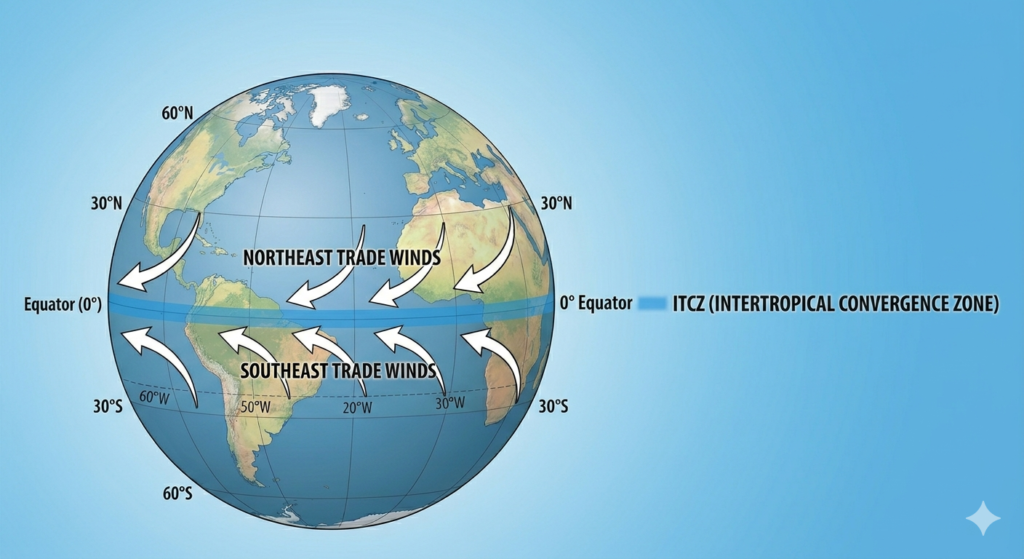
- Coriolis effect– The Coriolis effect is an inertial force caused by the Earth’s rotation. While it does not initiate wind movement, it dictates the direction in which air moves across the planet. Instead of blowing in a straight line from high-pressure poles to the low-pressure equator, the winds are deflected westward, creating the steady “Easterly” flow known as the Trade Winds. Due to the Earth’s rotation, the Coriolis force deflects moving air to the right in the Northern Hemisphere and to the left in the Southern Hemisphere.
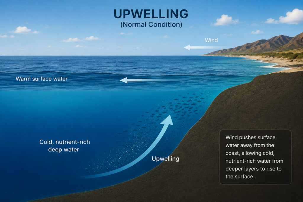
- Upwelling– It is the ocean cooling system, where strong winds push warm surface water away from a coastline, causing cold, nutrient-rich water from the deep ocean to rise up and take its place. Under normal conditions, the strong Trade Winds push warm surface water toward the West (Asia). This allows cold water to “upwell” along the coast of South America, keeping the Eastern Pacific cool.
1. Normal Conditions: The Balanced State
Under normal circumstances, the tropical Pacific follows a consistent, self-reinforcing cycle:
- Strong Trade Winds: These easterly winds blow steadily from East to West across the tropical Pacific.
- The Warm Pool: These winds push warm surface water toward Asia and Australia, causing it to “pile up” in the Western Pacific.
- Active Upwelling: As the warm surface water is pushed away from South America, cold, nutrient-rich water rises from the deep to replace it. This keeps the Eastern Pacific significantly cooler.
- Atmospheric Stability: This temperature difference dictates the weather. The “Warm Pool” in the West creates Low Pressure and heavy rain (Indonesia/Australia), while the cold water in the East creates High Pressure and stable air (Peru).
2. During El Niño: The Great Disruption
During an El Niño or super El Nino event, the balanced system of the Pacific Ocean significantly weakens or reverses:
- Weakening Trade Winds: The primary trigger occurs when the steady easterly Trade Winds stall or begin blowing from West to East.
- The Warm Wave: Without the force of the winds to hold it back, the massive pool of warm water accumulated in the West “sloshes” back toward the coast of South America.
- The End of Upwelling: This warm water pushes the thermocline (the boundary between warm surface water and cold deep water) much deeper, completely stopping the rise of cold, nutrient-rich water.
- Surface Warming: As a result, sea surface temperatures in the Central and Eastern Pacific rise significantly—sometimes by 2°C or more in the case of a “Super El Niño.”
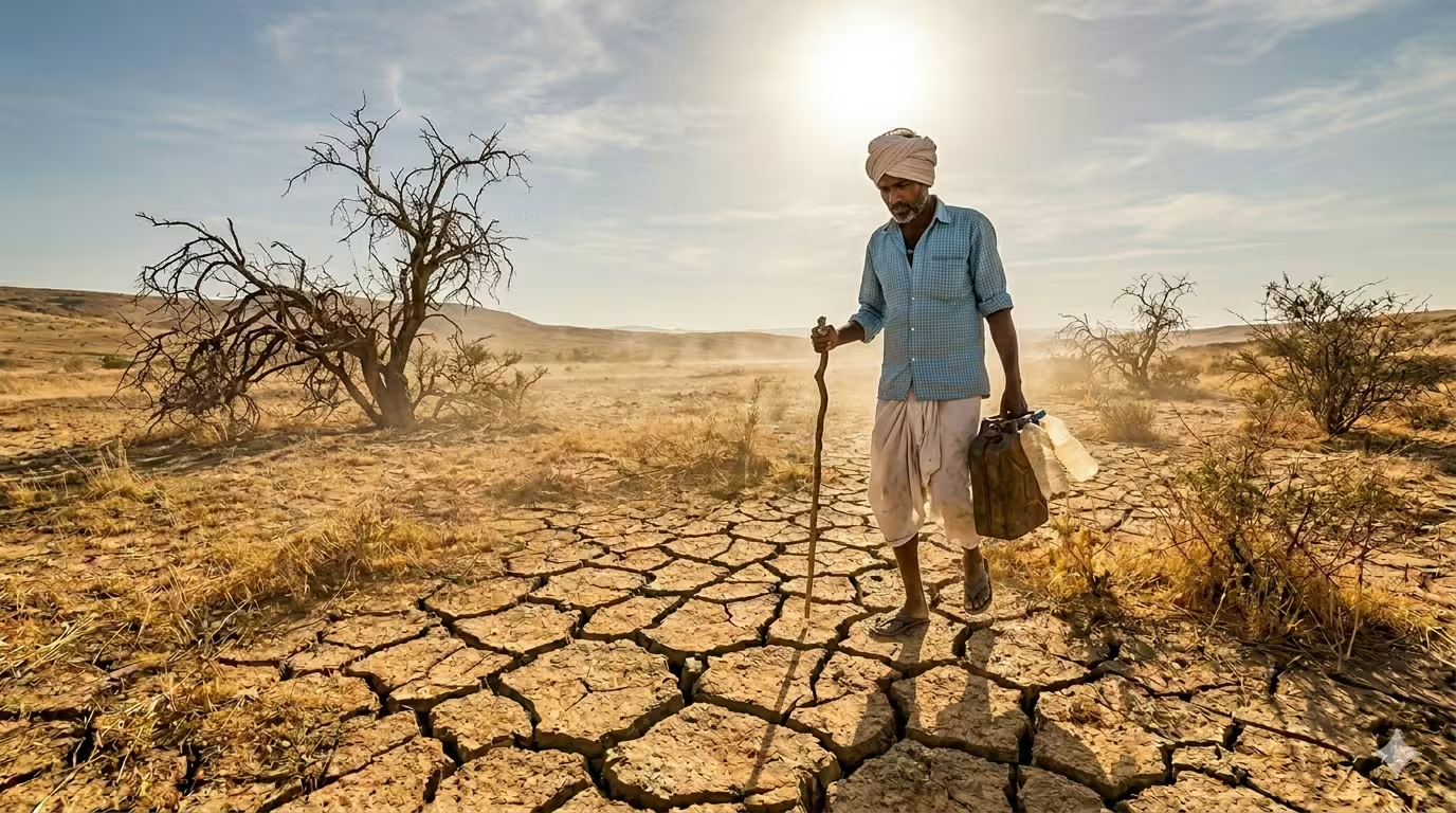
The warm water moves to the Central and Eastern Pacific, forcing the air to rise and creating massive thunderstorms in areas that are usually dry, which leads to heavy flooding in South America. Because this moisture and heat have moved away from the West regions like Australia and Indonesia face severe droughts and wildfires as their normal rain cycle fails. In Asia and India, this shift disrupts the seasonal monsoon by weakening the moisture-carrying winds, resulting in a major lack of rain, long dry spells, and intense heatwaves that impact farming and water supplies. This overall movement of heat across the ocean causes average global temperatures to rise and changes weather patterns across the entire planet.
1877-78 is remembered as one of the worst climate disasters ever recorded, associated to EL Nino. Research from NOAA and the American Meteorological Society shows just how dangerous these events can be:
- Massive Loss of Life: This single event caused severe droughts and famines that killed an estimated 50 million people around the world.
- Impact on India and China: India was hit extremely hard, losing between 12 and 29 million people. China lost nearly 30 million, and Brazil lost about 2 million.
- Disease Outbreaks: The extreme weather caused more than just hunger. It led to outbreaks of deadly diseases like malaria, cholera, and smallpox among people who were already weak from the drought.
The 1982-83 and 1997-98 cycles stand out as the intense El Niño occurrences recorded in the 20th century. During the 1982-83 period, the water at the surface of the eastern tropical Pacific became unprecedentedly hot, far exceeding normal seasonal levels. Later, the 1997-98 event made history as the first time scientists were able to scientifically monitor the entire cycle from start to finish.
The global effects of the 1997-98 event were extraordinary:
- In Asia: Countries like Indonesia, Malaysia, and the Philippines suffered through severe and prolonged droughts.
- In the Americas: Peru and California were battered by relentless heavy rains and catastrophic flooding.
- In the U.S. Midwest: The region experienced such extreme, record-breaking warmth that the period became known as ‘the year without a winter
La Niña: The Cooling Phase
The name La Niña is Spanish for ‘The Little Girl , and it represents the cooling phase of the ocean cycle. It is the direct opposite of El Niño and occurs when the Pacific’s natural “engine” goes into overdrive. During this time, the Trade Winds become much stronger than usual, pushing even more warm water toward Asia and Australia.
This movement causes a massive amount of cold, deep water to rise to the surface in the Eastern Pacific, leading to a significant cooling of the ocean. As a result, regions like India and Australia often see much heavier monsoon rainfall and cooler temperatures, while areas in South America experience very dry and stable weather.
The 2010 La Niña event was linked to some of the worst floods in the history of Queensland, Australia. Because this cooling phase brought much more moisture than usual to the area, it led to record-breaking rain that forced over 10,000 people to leave their homes for safety. The disaster caused great damage to the region, with the total cost of the destruction reaching more than $2 billion.
El Niño or super EL-Nino and La Niña events typically last between 9 to 12 months. While this is the usual timing, some stronger events can continue for several years.
Oceanic Niño Index (ONI)– The Oceanic Niño Index (ONI) is the standard tool used to identify, measure, and predict both El Niño or super El Nino and La Niña events. It works by tracking how much the sea surface temperatures in the east-central Pacific Ocean shift away from their normal levels.
Impact on the Aviation Industry
The extreme weather shifts caused by El Niño or super EL-Nino create significant challenges for flight operations and safety. The strengthening of jet streams often leads to more frequent Clear Air Turbulence (CAT), making flights less predictable for pilots. Additionally, the intense heat associated with these events can reduce air density, which negatively affects aircraft performance and may require weight restrictions for take-offs. Heavy rainfall and shifting wind patterns also increase the likelihood of widespread operational delays, rerouting, and potential damage to airport infrastructure.